

This post was intended to be my piece of extra information to accompany my story for FFfAW (here). As it became rather long (although it’s more pictures than information -some photos my own, others from Wikipedia) I’ve made it into a separate post. It’s about an area of England I’ve loved since I was a child – the Lake District. The information includes a little about the area today, and a little about it in the days when it was part of the old Celtic kingdom of Rheged, where my story takes place.
The Lake District – also known as The English Lakes or just Lakeland – is one of England’s most popular holiday destinations. It is one of the 13 National Parks of England and Wales (No. 2 on the first map below) which today is situated entirely in the county of Cumbria:


People are drawn to this area by the natural beauty of its mountains (fells), forests and many lakes. The highest mountain in England, Scafell Pike, lies within the Park’s boundaries . . .

. . . as does the longest and largest lake, Windermere . . .
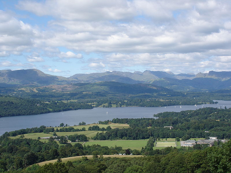
. . . and the deepest lake, Waswater (also shown on my first photo):

Unfortunately for the many holidaymakers, it does rain a lot up there! Seathwaite, in the Borrowdale area, holds the record for being the wettest inhabited place in England (130 inches of rain per year). But the many old towns tend to have lots going on, as we noted when we were in Keswick a couple of months ago:
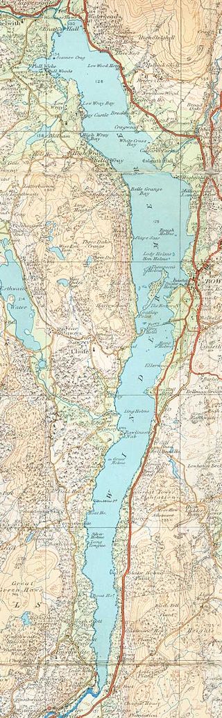
Evidence of glaciation during the last Ice Age, can be seen all over the Lake District. I won’t go into the many features other than those of the lakes. As the great glaciers moved out from the centre of the upland region, it gouged out the existing V-shaped valleys into the familiar U-shaped valleys with the ‘ribbon’ lakes we see today – as clearly shown on this O.S. map of Lake Windermere and the picture of Thirlmere below it:
Public Domain.

In the Lake District, the lakes radiate out from the central upland like the spokes of a wheel – which you can see in the second map on my post.
The area around Lake Windermere is one of the most popular tourist areas of the Lake District. Steam vessels of the late 19th century carried tourists the length of the lake . . .

. . . and nowadays modern ferries run continuously, many tourists heading for the town of Bowness (where we got off) halfway along the lake, or to Ambleside in the north.

There’s plenty to see along the route: there are 18 islands, various old buildings and private villas, and lots of yachts and other craft moored along private jetties. And motor boats and water skiers provide plenty of entertainment.
Other tourists visit The Lake District simply to see the land so loved by poets such as William Wordsworth and Samuel Coleridge, and the children’s author, Beatrix Potter. Wordsworth’s house in Grasmere, Dove Cottage, is a honeypot for tourists:

So many other books have been set in this wonderful place – Swallows and Amazons for one – and many contemporary ones.
Cumbria, along with parts of what is now Southern Scotland and further south, the English county of Lancashire, were thought to have once been what was the the Celtic Kingdom of Rheged, although its exact location and extent are still uncertain.

I won’t go into detail about this kingdom, except to say that it survived well into the 7th, possibly 8th century, when it was annexed by the Anglo-Saxon kingdom of Northumbria. Rheged had been a powerful kingdom in its time. King Urien in particular (c 530-590) is well known, having been written about by his bard, Taliesin. Both Urien and his son, Owain, became heroes in the stories about King Arthur and his fight against the invading Anglo Saxons. The Brynaich and Deifr on the map above became the A.S. kingdoms of Bernicia and Deira – which both became a part of Northumbria.
*
Finally, below is another of the the Lake District’s attractions – the Neolithic stone circle at Castlerigg – about which I have a post to do sometime soon.

